ROVR widened its network footprint with 2,451 users operating 1,631 devices, which have collected data across 16.74 million km of roads worldwide as of June 2025.
Eight enterprises have become global distributors of ROVR’s hardware, expanding ROVR’s commercial reach and accelerating device adoption. The team targets 10,000 TarantulaX and 1,000 LightCone units live by YE 2025.
LightCone’s (LC) second batch of pre-orders opens on June 16, 2025, with airdrop rewards and a September 2025 delivery date.
ROVR has signed multiple letters of intent (LOIs) and begun fulfilling paid contracts with international vendors for its decentralized HD Map and 3D generation datasets. A European partner is running a city-level PoC in Paris, and a Tier 2 automotive supplier has integrated ROVR 3D data into live production.
ROVR plans to open-source the world’s largest 3D dataset, similar in spirit to the Waymo Open Dataset, but significantly larger in scale and broader in geographic diversity. This dataset is designed to support a wide range of applications, including the training of autonomous driving systems, robotics, spatial AI, and world models.
Introduction
ROVR is a decentralized physical infrastructure network (DePIN) dedicated to constructing a comprehensive geospatial data platform through specialized hardware and software solutions. Its mission is to collect and produce large-scale, highly accurate 3D geospatial and 4D spatiotemporal data from real-world environments, addressing the critical bottleneck in quality 3D data availability. This data is vital for training and deploying advanced systems like autonomous vehicles, robotics, and spatial artificial intelligence solutions. By democratizing access to critical resources traditionally monopolized by large corporations, ROVR empowers individual contributors to participate directly in the economic benefits of the AI-driven economy.
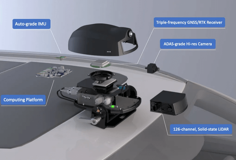
Data collection within the ROVR ecosystem relies on two specialized devices: the TarantulaX (TX) and the LightCone (LC). TarantulaX is a compact hardware device that mounts on the vehicle roof and links to a driver’s smartphone over Bluetooth. By feeding centimeter-level corrections from GEODNET, it turns everyday mobile video into accurate geospatial data. Meanwhile, the LightCone is a roof-mounted sensor that pairs an automotive LiDAR, ADAS-grade camera, tri-band RTK satellite antenna, and high-precision IMU to capture centimeter-accurate 3D data. Users who contribute quality data are rewarded with ROVR tokens, incentivized based on factors including the amount of data collected (measured in mapping mileage), data quality, and frequency of road re-visits.
The data gathered is subsequently transformed into high-definition (HD) maps that deliver centimeter-level precision and detailed environmental context, critical for applications such as autonomous vehicle navigation. ROVR's 3D data generation tools support the training of advanced AI models, enabling precise scene editing and the creation of synthetic data based on actual real-world conditions.
Background
ROVR was founded in March 2024 by Guang Ling and Xinran Li, alongside three other experienced team members, and established an office in the U.S. Bay Area in April 2025. The founders collectively bring relevant expertise with previous roles at Tencent, Alibaba, Baidu, the European Space Agency, and China Ping An Insurance. The team notably pioneered innovations such as the world's first purely visual, crowdsourced mapping algorithm and was involved in the R&D of Velodyne LiDAR in the APAC market.
ROVR secured initial funding in May 2024 through the Outlier DePIN Accelerator in collaboration with Borderless Capital and Peaq. This was followed by a pre-Seed funding round announced on June 25, 2024, raising $200,000 from Outlier Ventures. A year later, ROVR successfully closed a Seed round in April 2025, raising $2.6 million co-led by Borderless Capital and GEODNET, with additional participation from IoTeX.
The ROVR data network officially went live on Sept. 2, 2024. Concurrently, pre-sales for their initial hardware offering, the TarantulaX (TX), commenced in Q3 2024, achieving significant market traction with over 1,500 units delivered by late October and an additional 1,000 units ordered. Production and initial deliveries for the LightCone are anticipated to begin in Q2 and Q3 2025.
Technology
TarantulaX
TarantulaX (TX) is ROVR's initial hardware node, designed specifically to enable everyday drivers to efficiently collect high-precision geospatial data. The compact, waterproof device includes a dual-band L1/L5 GNSS receiver, an automotive-grade inertial measurement unit (IMU), and an integrated encryption chip for securing satellite observations. The TX significantly enhances the accuracy of smartphone GPS, from typical multi-meter inaccuracies to approximately one centimeter, by leveraging real-time kinematic (RTK) correction services provided by GEODNET.
Positioned on a vehicle’s roof and powered via USB, the TarantulaX communicates with a smartphone through Bluetooth, transmitting signed positional data. TarantulaX turns its raw GPS reading into a signed Global Positioning System Fix Data message (GGA) and beams it to the ROVR app via Bluetooth. The app sends that rough location to GEODNET through the Networked Transport of RTCM via Internet Protocol service (NTRIP), receives centimeter-level correction data in the Radio Technical Commission for Maritime Services format (RTCM), and returns the corrections to the TarantulaX so it can instantly recalculate an ultra-accurate GGA position.
At the same time, the phone’s camera records the driver’s view of the road, corrects lens distortion, and automatically detects lanes, traffic signs, and other roadway features. Then, it converts pairs of frames into small 3D map slices. Every 30 seconds, the app encrypts those slices with the corrected location track and uploads the bundle to ROVR, where overlapping uploads from many drivers are fused to hit the network’s 50 cm absolute and 20 cm relative accuracy targets, and the raw video is then discarded to preserve privacy.
Contributors earn rewards starting at 1.6 ROVR tokens per kilometer in the first year, with this rate halving annually thereafter. This reward structure emphasizes comprehensive, high-quality, and regularly updated data collection, discouraging redundancy through reduced rewards for overly frequent revisits. TarantulaX taps a driver’s smartphone for imaging and compute while its own RTK module handles secure centimeter-level positioning, creating an ultra-low-cost device that can blanket roads at scale and feed ROVR’s geospatial data network.
LightCone
LightCone is a more precise and automotive-grade sensor than TX, designed for high-speed collection of dense, centimetre-accurate 3D spatial data. TX helps scale reach while LC ensures the network has high-fidelity data. Central to its operation is an advanced solid-state LiDAR scanner that emits rapid laser pulses, measuring their return times to create precise point-cloud representations of surrounding environments. The sensor accurately captures distances within roughly 3cm at ranges up to 150m.
Complementing this system, an integrated high-resolution camera captures detailed imagery to enrich the spatial data with color and texture, while an automotive-grade inertial measurement unit (IMU) precisely tracks vehicle orientation and vibration. All collected data streams are anchored by centimetre-level GPS corrections sourced from GEODNET’s RTK network.
LightCone's onboard computer synchronizes data from the LiDAR scanner, camera, and IMU, securely digitally signing each dataset to ensure integrity and prevent fraud. The processed data is stored locally on a robust 1TB solid-state drive before being uploaded to ROVR’s backend infrastructure. There, data from multiple LightCone units are aggregated, refining the combined datasets to meet stringent accuracy standards, the same 50cm absolute accuracy and 20cm relative accuracy that applies to the TarantulaX device.
The use of LiDAR technology significantly addresses the limitations of traditional camera-based systems, which typically falter beyond short distances and are susceptible to depth estimation errors. The precision of LiDAR’s depth measurements enables developers to rigorously calibrate perception and autonomy algorithms, enhancing safety and reliability. Furthermore, LightCone data acts as a foundational calibration layer within ROVR’s broader network, providing high-quality baseline data that supports and validates contributions from less precise hardware such as TarantulaX.
LightCone contributors initially earn 16 ROVR tokens per kilometre, reflecting the complexity and higher fidelity of the data they provide. Rewards are subject to a structured evaluation emphasizing signal clarity, data novelty, and coverage breadth. This incentivizes high-quality, targeted data collection, strategically positioning LightCone as a critical component in building ROVR’s comprehensive, accurate, and decentralized 3D geospatial data ecosystem.
Use Cases
HD Mapping
ROVR’s high-definition (HD) mapping leverages advanced sensor technology to construct precise, detailed representations of real-world environments. These are critical for autonomous vehicles (AVs), urban management, and large-scale spatial analytics. HD maps integrate centimeter-level accuracy and rich environmental context, enabling various strategic and operational applications.
HD Map construction for AVs
With real-time HD mapping, ROVR improves navigation for autonomous vehicles by continuously capturing and updating essential road details such as lane markings, traffic signs, curbs, and barriers. Data collected by LightCone and TarantulaX devices is processed to maintain accurate and reliable maps, which are essential for safe and effective autonomous driving. This immediate, detailed feedback helps AV developers quickly refine vehicle perception systems and respond effectively to real-world driving conditions.
Surveying and city planning
For urban planners and city officials, HD mapping provides fresh, detailed views of city infrastructure. Real-time updates help planners quickly spot changes in roads, bridges, streetlights, and signage, improving their ability to manage and maintain these assets. With constantly refreshed data, cities can more efficiently plan new projects, swiftly address issues, and make informed decisions to enhance urban living.
Go Paris
The Go Paris project highlights ROVR’s real-world impact in creating live, city-wide HD maps. Initially launched as a demonstration for an undisclosed European partner, Go Paris tested ROVR’s ability to provide accurate, frequently updated maps even in cities without widespread Web3 adoption. From November 2024 to January 2025, the project has mapped about 126 square kilometers of central Paris in just seven weeks, covering over 1,500km of roads.
The mapping effort delivered impressive results, identifying around 36,930 traffic signs, 49,956 road markings, 15,653 crosswalks, and 208,780 lane markings spanning 6,000km. Independent validations showed high accuracy: 87.0% for traffic signs, 92.5% for road markings, and 90.7% for lane markings, with precise positioning consistently under 20cm.
The Go Paris initiative continues to expand coverage and data frequency, aiming to make its detailed maps publicly available soon.
Controllable Data Generation
ROVR’s controllable data generation provides a robust framework for capturing precise, customizable real-world data tailored for advanced AI training and simulation. Unlike conventional datasets, which often lack consistency and traceability, ROVR’s approach ensures data authenticity and verifiability, which is crucial for sensitive applications such as autonomous driving, robotics, and spatial AI.
Developers using ROVR’s LightCone hardware can precisely target and capture specific environments like urban centers, industrial zones, highways, or rural landscapes. All collected data, including LiDAR point clouds, high-resolution images, RTK GPS coordinates, IMU data, and sensor calibration parameters, is uniformly structured, enhancing usability and reducing preprocessing overhead.
ROVR’s infrastructure guarantees data integrity through cryptographic verification, allowing every data segment to include secure metadata such as exact location, timestamp, and positioning accuracy. Each dataset is traceable to its originating hardware and contributing user, ensuring a transparent and secure data chain, reinforced by onchain indexing and digital signatures.
The captured raw data is then fed into specialized AI pipelines, enabling advanced techniques like 3D Gaussian Splatting and Neural Radiance Fields (NeRF). These methods transform raw sensor inputs into sophisticated, customizable virtual environments, offering developers powerful tools for scene editing, synthetic data generation, and simulation training. For autonomous vehicles, this controllable data generation facilitates nuanced scenario testing, significantly improving safety and decision-making algorithms through realistic, editable training scenarios.
Humanoid Robot Training
ROVR’s controllable data generation is specifically suited to support the development of humanoid robotics. By capturing structured and highly detailed 3D point clouds and visual data, the platform provides a realistic and diverse set of scenarios for training humanoid robots. Data collected from varied indoor and outdoor environments is particularly valuable in replicating the complexities of real-world human perception.
Using ROVR’s platform, robotics developers can precisely adjust environmental conditions, ensuring their robots experience a broad spectrum of realistic scenarios. This precise control over data inputs accelerates the refinement of crucial robotic functionalities such as obstacle detection, precise motion planning, and comprehensive spatial awareness.
Tokenomics
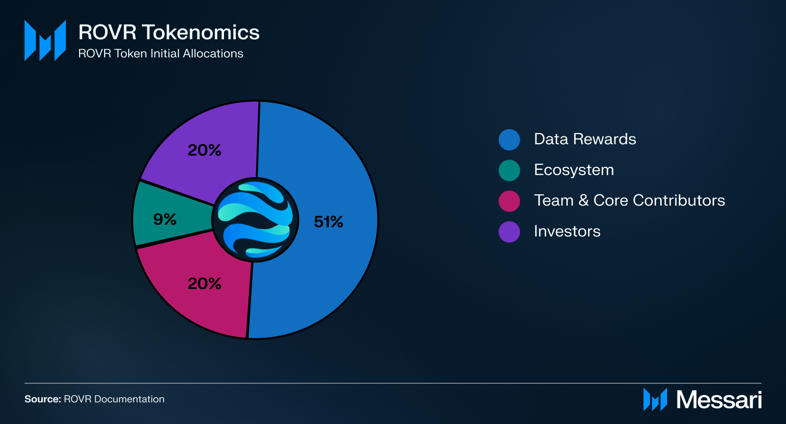
The ROVR token serves two purposes: it compensates contributors for gathering industry-grade spatial data and governs the long-term control of network resources. ROVR is deployed on the Solana network with a fixed total supply of 10B tokens. ROVR’s allocation is designed to support network sustainability and community engagement:
51% is allocated for community contributors, rewarding users who actively participate in data collection and network growth.
20% is designated for the founding team and core contributors, supporting ongoing research and system development. This allocation vests linearly over 36 months after a 9-month cliff.
20% is reserved for investors, with an initial release of 0.733% at the Token Generation Event (TGE), a 6-month lockup period, and linear vesting over 24 months.
The remaining 9% supports ecosystem activities such as liquidity provision, market operations, and promotions. 0.018% is available at TGE, and the remainder vests linearly over 12 months.
Incentive Mechanics
ROVR rewards contributors based on the quality and frequency of their data submissions, incentivizing high-quality and novel data collection. Initial base rewards are set at 1.6 ROVR per kilometer for TarantulaX users and 16 ROVR per kilometer for LightCone users, with the base reward halving annually post-TGE.
Data quality is automatically scored across factors such as clarity, lighting, RTK accuracy, and device compliance. Each upload is ranked into quartiles from A (100% payout) to F (0%), with an F assigned if multiple TX or LC units are detected on one vehicle. The network also implements diminishing returns for repeated road coverage within a week, full rewards for the initial two visits, and decreasing thereafter. Global road revisit records are reset weekly to maintain data freshness and encourage diverse coverage.
Additional reward multipliers may be applied to specific geographic areas or timeframes, driven by consumer demand for particular data attributes or locations, further aligning contributor incentives with market needs.
ROVR Flywheel
ROVR employs a burn mechanism driven by real-world demand for geospatial data. Revenue generated from data sales is systematically reinvested into the ecosystem via a token buyback and permanent burn model:
60% of the revenue from data product sales is allocated to buy back and permanently burn circulating ROVR tokens, reducing total token supply and potentially enhancing token value.
20% covers RTK service fees, specifically earmarked for purchasing and burning GEOD tokens from GEODNET, strengthening partnership integration.
The final 20% is dedicated to operational expenses, ensuring ongoing network maintenance and infrastructure improvements.
Roadmap
ROVR's roadmap outlines a multi-phase approach that aims to establish a robust, community-driven ecosystem for high-precision 3D data and spatial AI.
Q2 2024:
ROVR secured a $200,000 pre-seed funding round on June 25, 2024, led by Outlier Ventures, Borderless Capital, and Peaq.
Completed technical validation for decentralized HD mapping, ensuring platform readiness.
Q3 2024:
Began pre-sales of TarantulaX (TX).
Officially launched the ROVR data network on September 2, rapidly accumulating over 365,000km of data by late October (2.8M km by early January 2025).
Q4 2024:
Initiated pre-sales and Design Verification Testing (DVT) for LightCone (LC), a professional-grade LiDAR-based device.
Achieved significant TX device production, delivering over 1,500 units by late October, and an additional 1,000 units for November delivery.
Launched the "Go Paris" proof-of-concept (PoC) project on November 18, aiming to validate urban-scale HD mapping capabilities within a major European metropolitan area for a confidential automotive partner.
Q1 2025:
Officially released LightCone (LC) devices for testing, with 50 units distributed for a 2-month user validation period.
Successfully closed a $2.6M seed funding round co-led by Borderless Capital and GEODNET, with IoTeX participation on April 29.
ROVR Token Generation Event (TGE), launching on the Solana blockchain.
Q2 2025:
Initiate production of the second batch of LightCone after comprehensive global testing of the first batch of 50 units.
Pre-orders for the second batch of LightCone began on June 16, with delivery expected in September.
Implemented a streamlined token reward distribution mechanism effective July 1, ensuring timely contributor compensation and data freshness.
Ongoing and Future Initiatives
ROVR plans to open-source the world’s largest 3D dataset in Q4 2025.
Targeted delivery of 10,000 TarantulaX and 1,000 LightCone units by the end of 2025, with delivery of the second LC batch starting September..
Gradual decentralization of data reprocessing, empowering third-party organizations and developers to enhance and commercialize ROVR’s open datasets.
Planned public release of the comprehensive HD map data from the Go Paris project, accompanied by a web-based visualization platform to support open community access and broad utilization.
Closing Summary
ROVR is evolving into a real-time supplier of centimeter-level geospatial and 4D spatiotemporal data rather than a traditional mapping vendor. Its dual-device approach, low-cost TarantulaX for wide coverage and LightCone LiDAR rigs for high-fidelity depth, turns everyday driving into a rich, continuously updated data feed that meets strict absolute (50 cm) and relative (20 cm) accuracy targets. Since launching in September last year, contributors have uploaded 16.7 million km of signed sensor traces, validating the network’s scalability and accuracy in city-scale pilots such as Go Paris.
Key initiatives remain on the docket this year, including increased LightCone production, open-sourcing the world’s largest 3D dataset, and the introduction of Weekly Road Revisit Rewards Decay to incentivize quality contributions. These efforts should expand hardware capacity, lower processing costs, and scale the network, positioning ROVR as a foundational data layer for autonomous mobility, robotics, and spatial AI.
This report was commissioned by ROVR Foundation. All content was produced independently by the author(s) and does not necessarily reflect the opinions of Messari, Inc. or the organization that requested the report. The commissioning organization may have input on the content of the report, but Messari maintains editorial control over the final report to retain data accuracy and objectivity. Author(s) may hold cryptocurrencies named in this report. This report is meant for informational purposes only. It is not meant to serve as investment advice. You should conduct your own research and consult an independent financial, tax, or legal advisor before making any investment decisions. Past performance of any asset is not indicative of future results. Please see our Terms of Service for more information.
No part of this report may be (a) copied, photocopied, duplicated in any form by any means or (b) redistributed without the prior written consent of Messari®.
Youssef is a Research Analyst on the Protocol Research team. Prior to joining Messari, Youssef was a Product Analyst at Fidelity Digital Assets. Youssef graduated from Northeastern University, where he led the Northeastern Blockchain club as President.
Youssef is a Research Analyst on the Protocol Research team. Prior to joining Messari, Youssef was a Product Analyst at Fidelity Digital Assets. Youssef graduated from Northeastern University, where he led the Northeastern Blockchain club as President.